

Add GPS to a photo in seconds
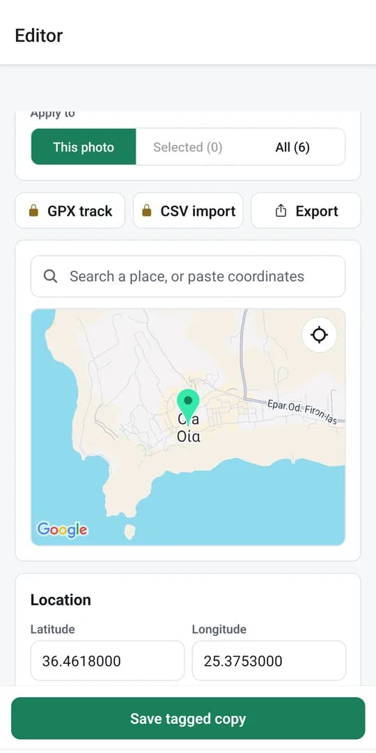
Search an address or click the map, and Geotagr writes the coordinates into your photo. It works on one photo or a whole batch, with nothing to install.
Geotagr is a free online photo geotagging tool that adds GPS coordinates, a description and keywords to your photos in seconds. Drop in a photo, pick the location, and download it ready for Google Business Profile, your website or your client. Everything runs in your browser, so your files are never uploaded.
Also on Android: get the Geotagr appNo software to install. Everything happens in your browser.
Drag in one photo or a whole job. JPG, PNG, HEIC and WebP all work.
Search a business name or address, or click the map. Geotagr fills in the latitude and longitude.
AI suggests a description and keywords, you edit them, then you download your geotagged photos.
Most geotaggers only write coordinates. Geotagr also writes the words Google reads.
AI looks at each photo and suggests an SEO description and keywords, written into the file.
Suggested keywords
Tag a whole folder of job photos with the same location in one click.
Type a business name or address and the pin lands in the right spot.
See the location and metadata inside any photo with our free checker.
Resize and convert to WebP or JPG while you tag, with presets for Google Business Profile and websites.
Get every tagged photo back in one file, ready to upload to Google Business Profile.
Photos are tagged in your browser and your files are never uploaded. AI suggestions send only a small preview of the one photo you ask about.
Geotagr is an online photo geotagging tool for people who publish local photos: contractors, agencies, real estate and photographers. Add GPS to a photo, write the description and keywords, and download files that carry their own location.
Search an address or click the map, and Geotagr writes the coordinates into your photo. It works on one photo or a whole batch, with nothing to install.
Read the GPS already inside a photo, change the coordinates, altitude and direction, or remove the location entirely. The tags are written as EXIF, with XMP and IPTC alongside, and checked after writing.
Add the location, business name, description and keywords before you upload job photos or storefront shots to your profile. Google decides how it uses photo metadata, so treat geotags as one helpful signal, not a promise.
Three free tools that run in your browser. No account needed.
The Geotagr app for Android tags photos right on your phone, the same way as the web editor. Pick the photos, set the location and save tagged copies to your library.
Try every Pro feature free for 7 days. No card needed. Cancel anytime.
$0 / month
$9 / month
$29 / month
Geotagging a photo means saving location data, usually latitude and longitude, inside the image file’s EXIF metadata. Phones do this automatically when location is on. For photos without it, a tool like Geotagr adds the coordinates afterwards.
Open Geotagr, add your photo, then search an address or click the map. Geotagr writes the coordinates into the file, and you download the geotagged photo. You can do it right away without signing up.
Yes. You can try Geotagr with no signup, and a free account lets you geotag photos every day. Free photos carry a small Geotagr mark; Pro removes it and adds larger batches and more AI suggestions.
Yes, from the version people see. Google strips metadata from the photos it displays on Business Profiles. Whether Google uses the original data internally isn’t public, so treat geotags as useful context, not a guaranteed signal.
No. Photos are read and tagged in your browser. The only exception is an AI suggestion: when you ask for one, a small reduced-size preview of that single photo is sent to our AI provider so it can write the text.
JPG, PNG, HEIC and WebP. JPG is the most widely supported format for geotags, so other formats are converted to JPG by default.
Yes. Bulk geotagging tags a whole set of photos with the same location in one click, and you can download them all as a ZIP. Larger batches are available on Pro and Business.
Use Geotagr’s free photo metadata checker. Upload a photo and it shows the location, coordinates and other metadata inside the file.
A short description of what’s in the photo and a set of relevant keywords, saved inside the image file. You can edit both before downloading.
Free to start, or every Pro feature free for 7 days. No card needed.